PeakFinder

4.7star
14.4K reviewsinfo
500K+
Downloads

PEGI 3
info


About this app
The mountains are calling! Explore more mountains than any mountaineer! PeakFinder makes it possible… and shows the names of all mountains and peaks with a 360° panorama display.
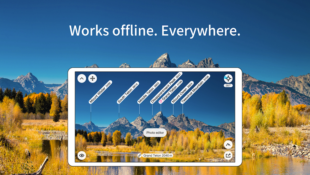
This functions completely offline - and worldwide!
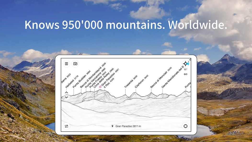
PeakFinder knows more than 1'000'000 peaks - from Mount Everest to the little hill around the corner.
•••••••••
Winner of several prizes. Highly recommended by nationalgeographic.com, androidpit.com, smokinapps.com, outdoor-magazin.com, themetaq.com, digital-geography.com, …
•••••••••
••• Features •••
• Works offline and worldwide
• Includes more than 1'000'000 peak names
• Overlays the camera image with the panorama drawing *
• Realtime rendering of the surrounding landscapes in a range of 300km/200mil
• Digital telescope to select less prominent peaks
• 'Show me'-function for visible peaks
• Selection of the viewpoint by GPS, the peak directory or an (online) map
• Mark mountains and places you like
• Can fly like a bird from peak to peak and vertically upwards
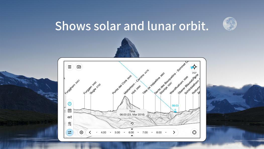
• Shows the solar and lunar orbit with rise and set times
• Uses compass and motion sensors
• Daily updates of the peak directory
• Does not contain any recurring costs. You pay only once
• Is free of advertising
* On devices without a gyroscope and a compass sensor the camera mode is not supported.
This functions completely offline - and worldwide!
PeakFinder knows more than 1'000'000 peaks - from Mount Everest to the little hill around the corner.
•••••••••
Winner of several prizes. Highly recommended by nationalgeographic.com, androidpit.com, smokinapps.com, outdoor-magazin.com, themetaq.com, digital-geography.com, …
•••••••••
••• Features •••
• Works offline and worldwide
• Includes more than 1'000'000 peak names
• Overlays the camera image with the panorama drawing *
• Realtime rendering of the surrounding landscapes in a range of 300km/200mil
• Digital telescope to select less prominent peaks
• 'Show me'-function for visible peaks
• Selection of the viewpoint by GPS, the peak directory or an (online) map
• Mark mountains and places you like
• Can fly like a bird from peak to peak and vertically upwards
• Shows the solar and lunar orbit with rise and set times
• Uses compass and motion sensors
• Daily updates of the peak directory
• Does not contain any recurring costs. You pay only once
• Is free of advertising
* On devices without a gyroscope and a compass sensor the camera mode is not supported.
Updated on
Safety starts with understanding how developers collect and share your data. Data privacy and security practices may vary based on your use, region, and age. The developer provided this information and may update it over time.

No data shared with third parties
Learn more about how developers declare sharing

This app may collect these data types
Personal info and App info and performance

Data is encrypted in transit

You can request that data be deleted
Ratings and reviews
4.7
14K reviews

Coen Hakeboom
- Flag inappropriate
August 25, 2023
The idea of the app is very nice, but there are some issues right now: 1) it doesn't access the location of pictures I want to import (despite it being in the metadata). 2) It doesn't handle landscape pictures well: the controls for adjusting the outline overlay are inverted. The names of mountains are all laid on top of one another and are thus illegible. 3) some mountains don't always show up, especially when close by.
11 people found this review helpful

Tomaash Cernik
- Flag inappropriate
September 14, 2024
Great app. Here's a feature idea. I mostly use this on my photos in post process, where there is often not enough room above the peaks for your labels. It would be ready handy if PeakFinder had the option to change the canvas size of the photo to make enough room for the labels above the peaks. And you could add styles of the transformation into a color of choice (black line, gradient, ai generated sky etc.). It would be especially useful since even apps like PS can't change canvas size. Thanks
55 people found this review helpful

Pavel Dvořák
- Flag inappropriate
- Show review history
July 29, 2025
it is a feature-packed app. I'm aware of the technical challenges involved but it works remarkably well! I always have to do some manual adjustments after taking a photo, but it always takes me less than a minute before getting the final result. it is super simple to use and intuitive. my favorite features: the air distance to peak and possibility to open the peak GPS in another app.
2 people found this review helpful
What’s new
Smaller optimizations and bug fixes.
App support
About the developer
PeakFinder GmbH
info@peakfinder.com
Eglistrasse 8
8004 Zürich
Switzerland
+41 77 499 61 00